
The short but sweet summer season here on the North Shore means capitalizing on every beautiful day—and there’s hardly a better way to enjoy the place we’re lucky to call home than by hiking the coast. From long, sandy stretches to breakers on rocky shores to wildlife spotting, the best features of the North Shore are on full display at these coastal reservations.
“Some of our most beautiful properties are on the North Shore,” says Aaron Gouveia, director of public relations for the Trustees of Reservations. Below, find some of our favorite spots for finding views and fresh sea air, along with tips, tricks, and pricing.
Atlantic Path, Rockport
The Atlantic Path is a system of public right-of-ways that stretches from Halibut Point State Park to Pigeon Cove, crossing both public land and private properties. Hugging the coastline, the path has been around in some capacity since the 1800s and offers uninterrupted views of the rocky coast and Atlantic Ocean. Access the trail from Gott Avenue, by the parking lot of Halibut Point State Park, or by multiple public footpaths between Atlantic Path and Phillips Avenue. Walkers are encouraged to note and be respectful of the places where the path traverses private land.
Gott Ave., Rockport, andrewswoods.org
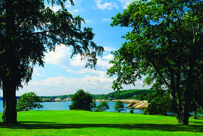
Coolidge Reservation, Manchester-by-the-Sea
A short wooded trail opens up to a vast seaside lawn with spectacular views at Coolidge Reservation in Manchester. The easy two-mile loop can be done in less than an hour, but the nooks and crannies of the reservation can fill hours—looking for snapping turtles around Clark Pond, taking the offshoot to Magnolia’s Gray Beach, and finding tidal pools in the glacial rock lining the shore.
“It combines many elements of what makes a coastal walk so special,” says Jared Bowers, property director of Coolidge Reservation, noting why he considers this spot his favorite North Shore coastal hike. While the trail is free, parking, off Summer Street, is very limited.
15 Coolidge Point, Manchester, 978-526-8687, thetrustees.org/place/coolidge-reservation
Crane Beach, Ipswich
One of the most iconic beaches in New England, Crane Beach balances conservation with recreation and welcomes 350,000 folks annually. While lounging on the sandy beach might be just the thing on a hot, sunny day, the reservation offers 5.5 miles of hiking trails through dunes, scrub forest, and beachfront. Trails are easy to moderate in difficulty, and the shortest loop clocks in at 1.7 miles. Advance pass purchase is required for parking, and starts at $15 per car for nonmembers.
310 Argilla Rd., Ipswich, 978-356-4354, thetrustees.org/place/crane-beach-on-the-crane-estate
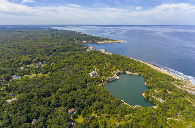
Goose Cove Reservation, Gloucester
This secluded 30-acre gem in Gloucester includes easy hiking through tidal mud flats, wooded upland, and rocky shoreline. Hundreds of years ago, Indigenous people living by Goose Cove would fish, gather spartina grasses for baskets, and quarry the granite and moraine stone for which Cape Ann is famous. Today, folks appreciate this Essex County Greenbelt reservation for its kayaking, scenic views, birding, cross-country skiing, and varied flora and fauna like otters and honeysuckle. Timing, however, is everything—the reservation’s parking lot, off Route 127, has only five spots.
Washington St., Gloucester, ecga.org/property/goose-cove-reservation
Halibut Point State Park, Rockport
Halibut Point State Park, located at the northernmost tip of Cape Ann, affords breathtaking views of the Atlantic Ocean and, on clear days, New Hampshire and Mount Agamenticus in Maine. The historic park has a visitor center (with restrooms), teaching folks about Halibut Point’s World War II history and the significance of Cape Ann’s granite industry. The graded hiking makes Halibut Point fairly accessible, and there are plenty of spots to lay out a picnic or traipse through the park’s trails and tidal pools. Daily parking is $8 for Massachusetts residents and $30 for nonresidents.
4 Gott Ave., Rockport, 978-546-2997
Misery Islands, Salem
Venture out across the water of Salem Sound and you’ll be rewarded with the meadows, beaches, tree groves, and spectacular views of the Misery Islands. While 83-acre Great Misery and 4-acre Little Misery were named by a shipbuilder stranded on the islands for “three miserable days” during a winter storm in the 1620s, the Trustees’ property on a summer day is closer to heavenly. The islands are free and open to all, but accessible only if you have a kayak, canoe, or dinghy to travel the half mile from the shores of Beverly. Once on Great Misery, venture along the two and a half miles of trails, have a picnic lunch, or wade over to Little Misery at low tide.
Salem Sound, Salem, 978-526-8687, thetrustees.org/place/misery-islands
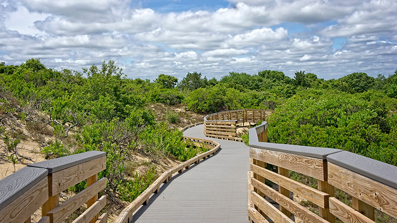
Parker River National Wildlife Refuge, Plum Island
The Parker River Refuge, spanning the southern three-quarters of Plum Island from Newburyport to Ipswich, is one of the larger nature reserves in Massachusetts at 4,700 acres and six miles long. Established in 1941, the refuge includes upland, dunes, salt marshland, and accompanying creeks and mud flats. The refuge is hugely significant to wildlife like migratory birds, especially threatened species like the piping plover, egrets, and snowy owls. Hellcat Boardwalk Trail, the refuge’s most popular designated hiking trail, is an easy 1.3-mile, wheelchair-accessible loop across boardwalk, great for wildlife spotting.
6 Plum Island Turnpike, 978-465-5753, fws.gov/refuge/parker-river
Ravenswood Park, Gloucester
Ravenswood’s 600 acres of wooded trails, opening out to Gloucester Harbor, were conserved by 19th-century businessman and philanthropist Samuel Sawyer. Ten miles of trails and carriage paths wind through woodland, pastures, swamps, and the rocky overlook at the harbor. You’ll find ample spots for picnicking, birdwatching, and mountain biking on designated trails. The park is free and open sunrise to sunset, year round.
481 Western Ave. (Route 127), Gloucester, 978-526-8687, thetrustees.org/place/ravenswood-park
Salisbury Beach State Reservation, Salisbury
The northernmost coastal reservation in Massachusetts, Salisbury Beach stretches 3.8 miles from the mouth of the Merrimack River to the New Hampshire border. Stroll along the sprawling, sandy beach, venture onto the boardwalks over the dunes, visit the education center, or have a picnic by the ocean. The reservation is also popular for boating or camping, with 484 campsites, public restrooms and showers, and water and electric hookups. While harbor seals sun themselves in the winter, warmer months bring birds like herons and sandpipers. Salisbury Beach is one of the highest trafficked state parks in the Commonwealth, with one million visitors annually. Parking is $14 for Massachusetts residents and $40 for nonresidents.
State Reservation Rd., Salisbury, 978-462-4481, mass.gov/locations/salisbury-beach-state-reservation
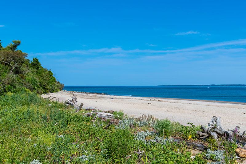
Sandy Point State Reservation, Ipswich
Sandy Point is the southern tip of Plum Island, six miles south of the Plum Island Turnpike and the entrance to Parker River Wildlife Refuge. Three of those six miles are gravel, and once you get down to Sandy Point’s parking lot there are only about 40 spots—but when you’ve made it to the reservation you’ll be greeted with a vast expanse of beach that never gets crowded, warm tidal pools as the tide goes in and out, and miles of walking potential. Sandy Point beachgoers can swim either on the ocean side or the Plum Island Sound side. The only cost to enter Sandy Point is the five dollars you pay to enter the Parker River Refuge.
Parker River Wildlife Refuge Rd., Ipswich, 978-462-4481, mass.gov/locations/sandy-point-state-reservation